Barton Creek Greenbelt Complete Guide
Every trailhead, swimming hole, and route on Austin's most popular trail system
#1 ABoR Team 2024$1B+ Career Sales1,000+ Homes Sold
The Barton Creek Greenbelt is a 13-mile limestone corridor running through the heart of West Austin, from Zilker Park to the Loop 360 trailhead near Lost Creek. It is the most used trail system in Central Texas and the single biggest lifestyle draw for buyers in the surrounding neighborhoods. The greenbelt follows Barton Creek through a canyon carved into Edwards Limestone, creating swimming holes, cliff faces, and old-growth cypress groves that feel nothing like the suburban streets a quarter mile above. When the creek is running, Sculpture Falls and Twin Falls draw hundreds of swimmers. When it is dry, the exposed limestone makes for excellent trail running. Either way, it is the reason half of West Austin pays a premium for greenbelt-adjacent lots.
Trail Map
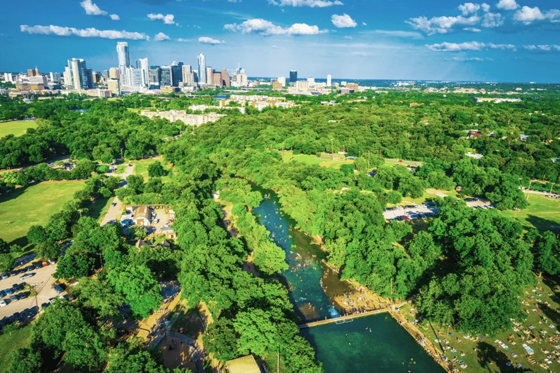
Barton Creek Greenbelt - Zilker Trailhead to Sculpture Falls
Highlights
- Sculpture Falls - the most popular swimming hole on the greenbelt
- Flat creek-bed hiking when water is low
- Old-growth bald cypress trees along the creek
- Rock scrambling sections kids love
Parking
Zilker Park parking lot (free weekdays, $5 weekends). Enter from Barton Springs Road.
Local Tip
Park at the Spyglass trailhead instead of Zilker to cut 0.5 miles off the walk to Sculpture Falls and avoid the Zilker parking crowds.
Twin Falls via Gus Fruh Trailhead
Highlights
- Twin Falls - two-tier waterfall with deep swimming pool
- Cliff jumping spot (15-20 feet, check depth before jumping)
- Steep descent into the canyon - good workout on the way back up
- Best swimming hole when the creek is flowing
Parking
Gus Fruh trailhead parking on Barton Hills Drive. Limited spots - arrive before 10 AM on weekends.
Local Tip
The upper pool at Twin Falls is often less crowded than the lower. Take the scramble trail left at the bottom to reach it.
Campbell's Hole via Spyglass Trailhead
Highlights
- Deep swimming hole popular with dogs and families
- Flat, easy trail along the creek bed
- Rope swing (conditions vary)
- Good for wading when water is low
Parking
Spyglass trailhead on Spyglass Drive. Street parking available when lot is full.
Local Tip
Campbell's Hole fills up fast on hot weekends. Wednesday afternoons are the sweet spot - warm enough to swim, empty enough to enjoy it.
Loop 360 Trailhead to Hill of Life
Highlights
- The Hill of Life - a notorious steep climb that trail runners use for training
- Technical rocky terrain excellent for mountain biking skills
- Views of the Barton Creek canyon from the rim
- Less crowded than the eastern trailheads
Parking
Loop 360 trailhead parking lot on the west side of Capital of Texas Highway, south of Barton Creek.
Local Tip
Trail runners park at 360 and run the Hill of Life repeats for interval training. Three climbs and you've earned your breakfast tacos.
Camp Craft Road to Sculpture Falls
Highlights
- Quieter approach to the central greenbelt
- Passes through the most remote section of the trail
- Old homestead ruins along the creek
- Best section for birding - golden-cheeked warblers in spring
Parking
Camp Craft Road trailhead. Small lot, arrives early on weekends.
Local Tip
This is the local's approach to Sculpture Falls. While tourists pack the Zilker end, you'll have the first two miles nearly to yourself.
Barton Springs Pool to Barton Creek Greenbelt
Highlights
- Start with a swim at Barton Springs (68 degrees year-round)
- Flat paved path transitions to natural trail
- Great for strollers on the first half mile
- Connect to the full greenbelt system going west
Parking
Zilker Park main lot or Barton Springs Pool lot ($5-$8).
Local Tip
Swim at Barton Springs first, then hike the greenbelt in the afternoon when the trees provide shade. The paved section near Zilker is stroller-friendly.
Nearby Neighborhoods
Looking for a home near these trails? These neighborhoods have the best access.